What Really Causes Tornadoes? Inside the Science of Tornado Formation
When a sudden, swirling column of air lashes the ground, the world watches in awe and fear. At first glance, tornadoes seem like chaotic whirlwinds, but meteorologists know that their birth is a highly structured, physics‑driven process. Understanding tornado formation involves piecing together a chain of atmospheric conditions that create the perfect environment for these violent vortices.
The Build‑Up: A Quick Overview
Before a tornado appears, a storm system has already been primed by a mix of heat, moisture, wind patterns, and atmospheric instability. Think of it as a kitchen where each ingredient must be at the right temperature and concentration before the recipe can finish cooking. In the atmosphere, these ingredients play out in layers, each affecting the next.
Key Ingredients of Tornado Genesis
1. Moisture – Warm, humid air provides the energy needed for thunderstorm development.
2. Instability – A steep temperature gradient allows air parcels to rise rapidly.
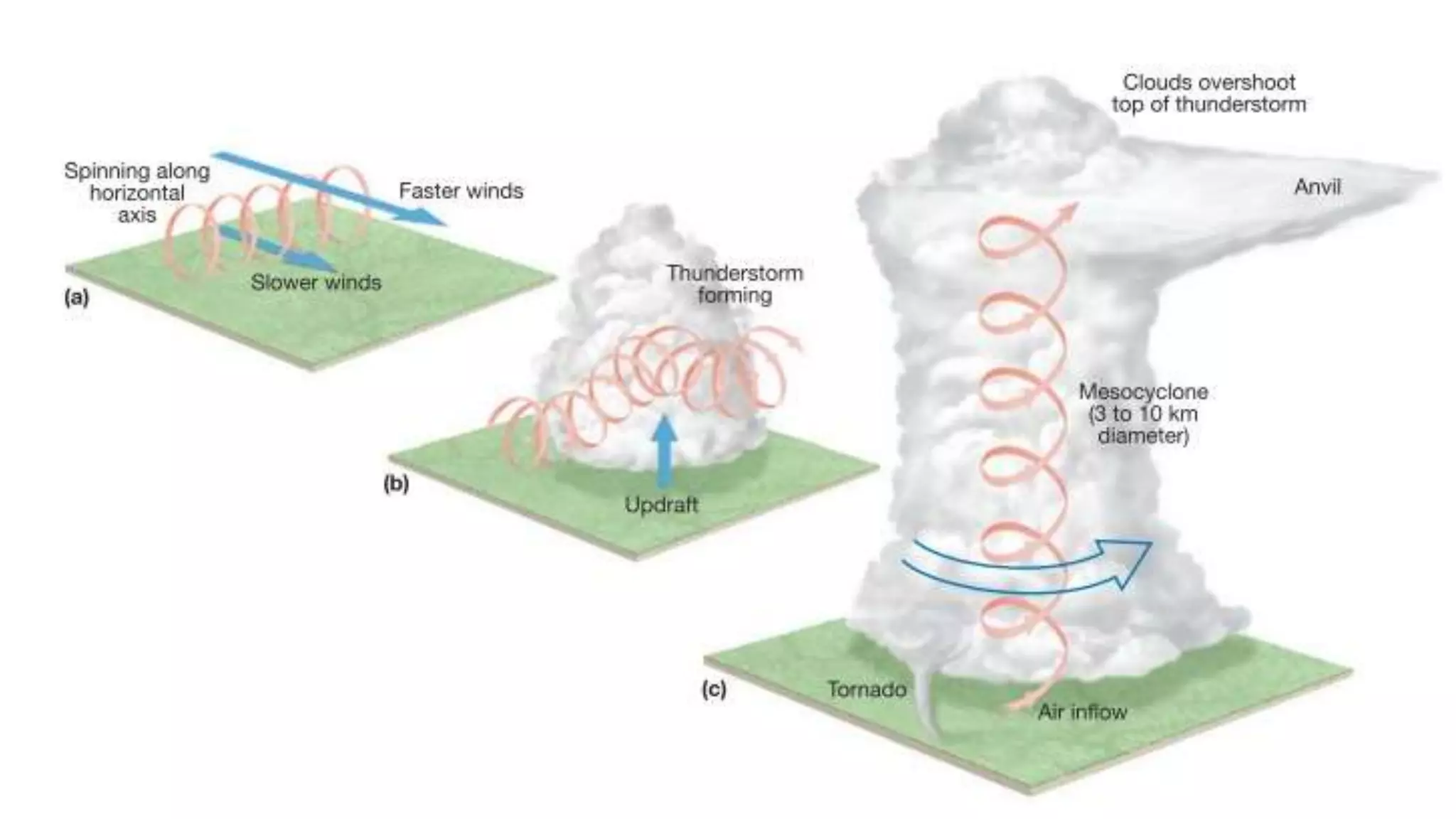
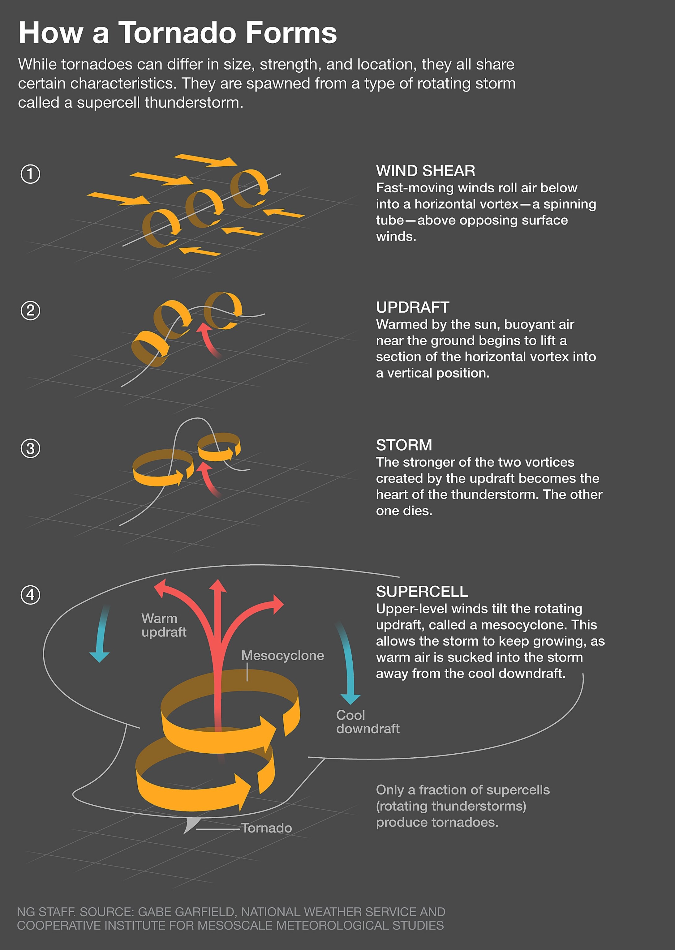
3. Wind Shear – Changes in wind speed and direction with height create horizontal spinning.
4. Lift – A surface or upper‑level feature forces air upward, triggering cloud and storm formation.
The Role of Atmospheric Instability
Instability is the engine that drives convective storms. When the air at the surface is significantly warmer than the air aloft, the warm parcels rise. As they ascend, they cool and condense, releasing latent heat that fuels further ascent. This feedback loop can build a towering cumulonimbus cloud capable of producing lightning, hail, and, under the right conditions, a tornado.
Wind Shear and Mesocyclones
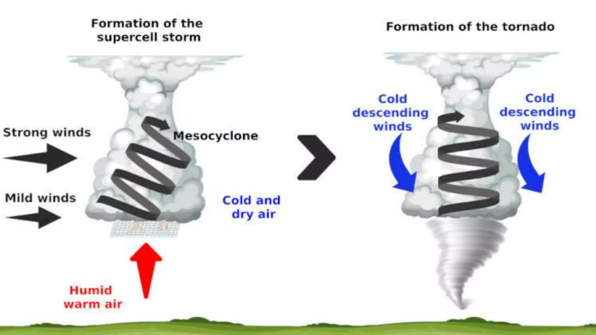
Wind shear is the twist in the air column. Imagine stirring a pot; the upper layers may rotate faster or in a different direction than the lower layers. This horizontal spin becomes vertical when a thunderstorm’s updraft tilts the wind shear, creating a rotating updraft called a mesocyclone. Mesocyclones are the hallmark of supercell thunderstorms, the most prolific tornado producers.
From Horizontal to Vertical Twist
The transformation from horizontal to vertical rotation involves two key processes:
- Updraft tilting: The strong upward motion of the storm tilts the wind shear.
- Stretching: As the mesocyclone gains vertical extent, it stretches, intensifying the rotation.
When the rotation is strong enough and the storm structure is stable, the mesocyclone can feed a tornado.
Supercell Thunderstorms: The Tornado Factory
Supercells are the elite of storm types. They feature a persistent, rotating updraft that can last several hours. Within the supercell, the mesocyclone feeds a narrow downdraft known as a rear‑flank downdraft. This downdraft pushes the rotating air downward, forcing it toward the surface and forming the tornado.
Typical supercell conditions include:
- Warm, moist air at the surface.
- A dry, cold air layer aloft that sharpens the wind shear.
- A strong, well‑defined updraft that sustains the mesocyclone.
These elements create a self‑reinforcing system, allowing the tornado to remain attached to the storm for extended periods.
Rare but Powerful: Non‑Supercell Tornadoes
Not all tornadoes arise from supercells. Flash‑over, land‑spike, and outflow‑bound tornadoes can form in environments with less organized storms. For example, the interaction of a cold front with a pre‑existing squall line can spin up a tornado even without a supercell’s rotating updraft. Although less common, these tornadoes can still reach significant intensity.
When Tornadoes Take Off: The Final Twist
Once the rotating updraft and downdraft are in place, the tornado’s formation hinges on a delicate balance of pressure, temperature, and moisture. The downdraft’s cold, dry air collapses onto the ground, forcing the rotating column to compress. If the pressure gradient becomes steep enough, a tornado can lift off the surface, becoming a visible, destructive vortex.
Forecasting and Warning
Modern meteorology leverages Doppler radar, satellite imagery, and atmospheric soundings to detect the precursors of tornadoes. Radar signatures such as a hook echo or a velocity couplet—two regions of opposing wind direction—are key indicators of a developing tornado. By identifying these patterns early, forecasters can issue watches and warnings, giving people precious minutes to seek shelter.
Key Warning Signs
- Rapidly rising thunderstorm intensity.
- Visible rotation on radar or satellite.
- Sudden changes in local wind direction.
Despite advances, predicting the exact location and strength of a tornado remains challenging. Still, understanding the underlying causes has dramatically improved response times.
FAQs About Tornado Formation
Q: How fast can a tornado spin?
A: Tornadoes can rotate between 200 and 600 miles per hour, but the most intense ones—rated EF4 or EF5—can exceed 300 mph.
Q: Do tornadoes always form from supercells?
A: Most do, but isolated supercells are not the only source. Flash‑over and outflow‑bound tornadoes can arise in other storm setups.
Q: Can we stop a tornado from forming?
A: Currently, it is impossible to alter atmospheric conditions on that scale. The best protection lies in early warning systems and sturdy shelters.
By piecing together the chain of atmospheric events—from heat and moisture to wind shear and rotation—meteorologists can demystify the violent birth of tornadoes. While the phenomenon remains one of nature’s most dramatic displays, the science behind its formation offers a roadmap for better forecasting and safer communities.